
San Francisco Bay Area War
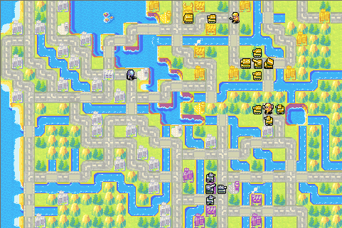
A fictional conflict across a detailed recreation of the southern San Francisco Bay Area.
Map created 2007.
Southern San Francisco Bay Area.
Team 1:
BH (Pacific Coalition)
vs.
Team 2:
YC (Bay Alliance)
Neutral:
Foster City
This scenario recreates the southern San Francisco Bay Area using real cities, airports, highways, and geographic landmarks. Although the battlefield is based on real-world locations, the conflict itself is entirely fictional.
The Pacific Coalition (BH) controls Santa Clara County, including San Jose and Santa Clara, while the Bay Alliance (YC) holds positions throughout Alameda County, including Hayward, Cherryland, and Union City. Foster City begins as neutral territory, making it a valuable strategic objective between the opposing coalitions.
Major airports—including San Jose International, Hayward Executive, San Francisco International, San Carlos, and Moffett Field—serve as critical transportation hubs, while an extensive freeway network recreates the strategic importance of highways 1, 17, 84, 92, 101, 238, 280, 580, 680, and 880. Several connections have been adjusted slightly to improve gameplay balance while preserving the region's recognizable geography.
Bases:
• Pacific Coalition (BH): Santa Clara, San Jose
• Bay Alliance (YC): Hayward, Cherryland, Union City
• Neutral: Foster City
Airports:
• Pacific Coalition: San Jose International
• Bay Alliance: Hayward Executive
• Neutral: San Francisco International, San Carlos, Moffett Field
Will you secure control of Silicon Valley and the East Bay, or will your opponent dominate the southern San Francisco Bay Area?
Southern San Francisco Bay Area.
Team 1:
BH (Pacific Coalition)
vs.
Team 2:
YC (Bay Alliance)
Neutral:
Foster City
This scenario recreates the southern San Francisco Bay Area using real cities, airports, highways, and geographic landmarks. Although the battlefield is based on real-world locations, the conflict itself is entirely fictional.
The Pacific Coalition (BH) controls Santa Clara County, including San Jose and Santa Clara, while the Bay Alliance (YC) holds positions throughout Alameda County, including Hayward, Cherryland, and Union City. Foster City begins as neutral territory, making it a valuable strategic objective between the opposing coalitions.
Major airports—including San Jose International, Hayward Executive, San Francisco International, San Carlos, and Moffett Field—serve as critical transportation hubs, while an extensive freeway network recreates the strategic importance of highways 1, 17, 84, 92, 101, 238, 280, 580, 680, and 880. Several connections have been adjusted slightly to improve gameplay balance while preserving the region's recognizable geography.
Bases:
• Pacific Coalition (BH): Santa Clara, San Jose
• Bay Alliance (YC): Hayward, Cherryland, Union City
• Neutral: Foster City
Airports:
• Pacific Coalition: San Jose International
• Bay Alliance: Hayward Executive
• Neutral: San Francisco International, San Carlos, Moffett Field
Will you secure control of Silicon Valley and the East Bay, or will your opponent dominate the southern San Francisco Bay Area?
Comments
Recommended by 0 players.